Mitigating Underwater-Noise Transmission and Effects Decision Support System (MUTE-DSS)
Project Snapshot
- Project Title: Mitigating Underwater-Noise Transmission and Effects Decision Support System (MUTE-DSS)
- Type: Research Project
- Concepts:
- Underwater Radiated Noise (URN)
- Ship Voyage Optimization
- Acoustic Propagation Modeling
- Marine Mammal Behavior Modeling
- Route Planning
- Speed Optimization
- Simulation
- Visualization
- Duration: 2024 - Ongoing
- Skills Developed:
- Acoustic Modeling: JOMOPAN-ECHO model, 3D Bellhop model, RBF interpolant, Reduced-order model
- Marine Robotics: ROS-based systems
- Optimization Algorithms: Genetic Algorithms, BIT* algorithm
- Simulation and Visualization: ROS, Rviz2, PlotJuggler
- Data Analysis: AIS data processing, Kernel Density Estimation
- Programming: Python, Open Motion Planning Library (OMPL), pymoo, sklearn
Project Overview
Abstract
The underwater radiated noise (URN) from ships poses a significant threat to marine mammals, given their heavy reliance on hearing. URN from ships is influenced by various factors, including ship characteristics such as type, propeller design, and hull dimensions, as well as operational characteristics like vessel speed and loading condition. The intensity of URN is heavily correlated with vessel speed, making speed reduction a crucial mitigation strategy. While numerous commercial systems and academic research focus on ship voyage optimization at the operational level to reduce fuel consumption, emissions, and improve safety, they often overlook noise impact.
To address this gap, this project presents an approach to reduce the impact of URN at the operational level by developing a Decision Support System (DSS) for ship voyage planning aimed at minimizing the maritime noise footprint. The proposed DSS performs route planning and speed optimization, making ships adaptive and acoustically aware of their footprint. The approach comprises three processes: Modeling, Optimization, and Simulation.
In modeling, a regression-based reference spectrum model is used for near-field noise modeling. For far-field noise modeling, a Gaussian beam method is used to generate data on underwater acoustic propagation loss, which is then used to build, validate, and integrate reduced-order models into the DSS. Regarding optimization, ship route planning is performed using a combination of graph and sample-based algorithms, while speed optimization is achieved using an evolutionary algorithm, aimed at minimizing the noise impact under voyage constraints. For simulation, a ROS-based system is presented, allowing users to simulate the interaction between adaptive ships and marine mammals—specifically the Southern Resident Killer Whales (SRKW)—in a 3D environment with realistic environmental conditions such as sound speed profiles and bathymetry.
To demonstrate our approach, real-world case studies are simulated in the DSS based on AIS data of ships operating from the Strait of Georgia to the Strait of Juan de Fuca. A comparative analysis of the noise levels associated with the optimized and unoptimized operation conditions is presented, showcasing the practical applicability of the proposed DSS.
Figure 1: Demonstration video of 3D ship navigation to minimize noise impact using ROS-based DSS.
Introduction and Background
Research Question
How can we develop a methodology or framework to support better decision making for marine operational conditions in order to minimize the impact of underwater radiated noise?
The proposed system, named Mitigating Marine Underwater-Noise Transmission and Effects Decision Support System (MMUTE-DSS), aims to achieve the aforementioned objectives. Rather than following traditional methodologies, where a ship operates based on policy measures designed by marine conservation programs, we propose a decision support framework that integrates inputs from ship characteristics, operational conditions, and environmental factors, providing real-time feedback to adapt the ship’s operations dynamically.

Figure 2: MUTE-DSS Workflow illustrating the decision support system architecture.
Methodology
1. Mathematical Modeling
A 3D environment is simulated with the ship traveling from departure to destination under voyage constraints. The ship operates within a spatial region containing moving marine mammals and dynamically adjusts its speed and route based on the noise soundscape feedback, optimizing to minimize its influence on nearby marine life. This adaptive response necessitates comprehensive models that capture the acoustic impact of various ship voyage scenarios and their interactions with marine mammals. This modeling approach is divided into three phases:
- Phase 1: Setting up the voyage problem and gathering all essential data required for accurate modeling in later phases. This includes defining voyage parameters, such as departure and destination locations, and compiling a comprehensive database consisting of ship data, environmental data, and marine mammal data.
- Phase 2: Pre-computation of models essential for the optimization process. This involves preparing the data for use within the modeling unit, including the ship noise signature model (using the JOMOPAN-ECHO model), acoustic propagation model (using the 3D Bellhop model), and the marine mammal trajectory and distribution model.
- Phase 3: Runtime phase where all components are integrated to simulate a realistic ship voyage scenario. This includes an optimization unit that performs route planning and speed optimization, and a simulation unit that utilizes precomputed models to estimate the soundscape along the ship’s route.
2. Workflow
The workflow starts with the operator providing the voyage configuration, which includes details regarding the voyage and the number of marine mammals in the environment. The simulation unit initializes the ship and disperses the specified number of mammals, activating the time scheduler and logging units. The optimization unit guides the ship's optimal operating conditions toward the destination by integrating both speed optimization and route planning. The simulation unit receives feedback on the ship's speed and route, forming a continuous feedback loop. The operation scenario is visualized through the interactive visualization unit, and finally, the logged data and optimal operating conditions are provided to the operator.
3. Database Unit
The database unit is categorized into data necessary for acoustic modeling and data pertinent to modeling marine mammals. The study area encompasses the waters of the Juan de Fuca Strait, the Strait of Georgia, Puget Sound, and Haro Strait. Data collected includes:
- Ship Data: Characteristics and design parameters for modeling noise source levels, such as engine specifications, hull design, and dimensions.
- Environmental Data: Oceanographic factors like sound speed profiles, bathymetry, bottom composition, and surface state, necessary for the acoustic propagation model.
- Marine Mammal Data: Distribution, species-specific behavior, and movement trajectories of marine mammals within the operational region.

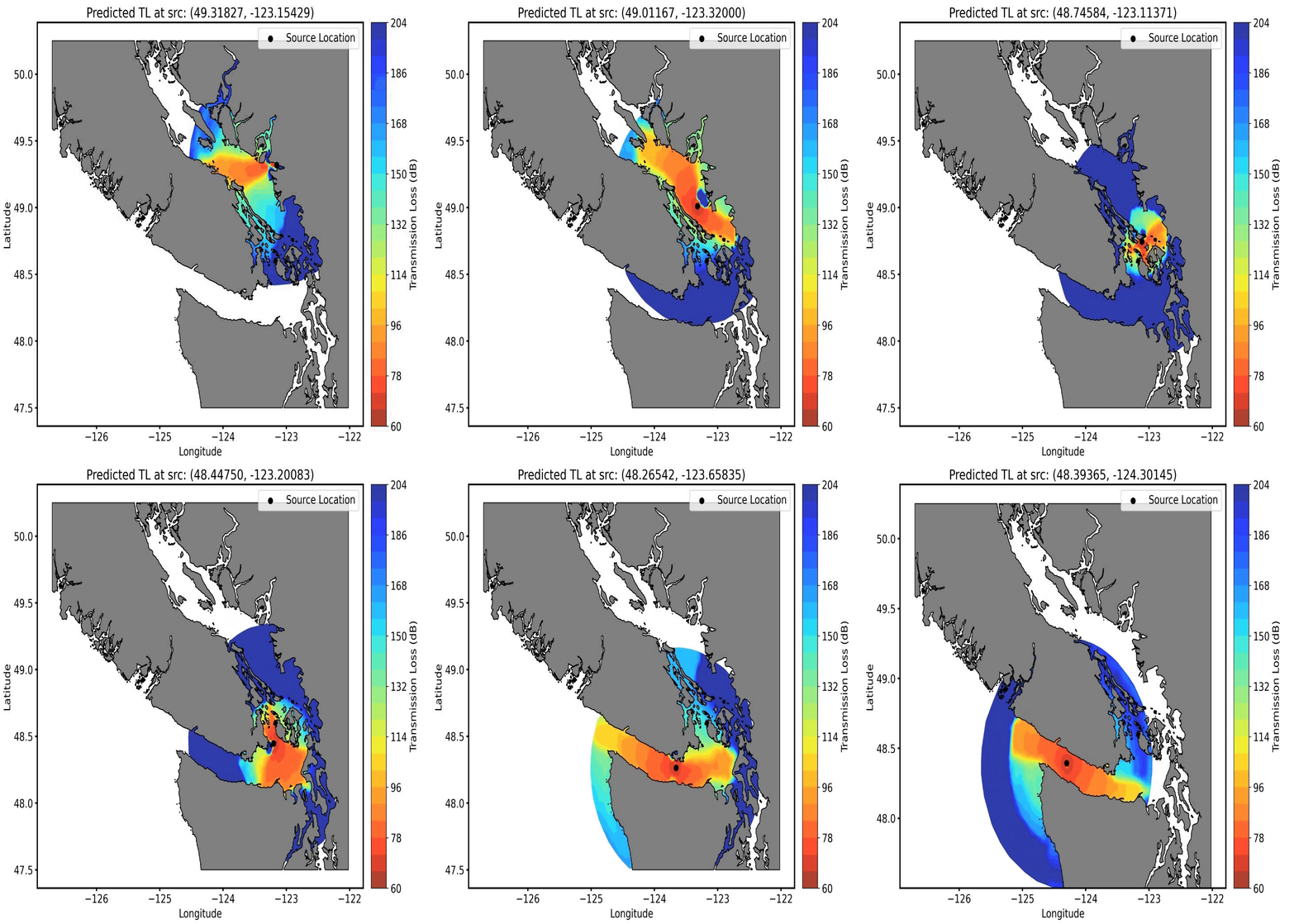
Figure 4: Gaussian RBF interpolant for propagation loss approximation.
4. Acoustic Modeling Unit
In this study, noise source levels (NSL) and transmission loss (TL) are computed for frequencies within the 12.5 Hz to 10k Hz range:
- Near-Field Noise Modeling: Utilizes the JOMOPAN-ECHO model to calculate the ship's noise signature dynamically during the optimization process.
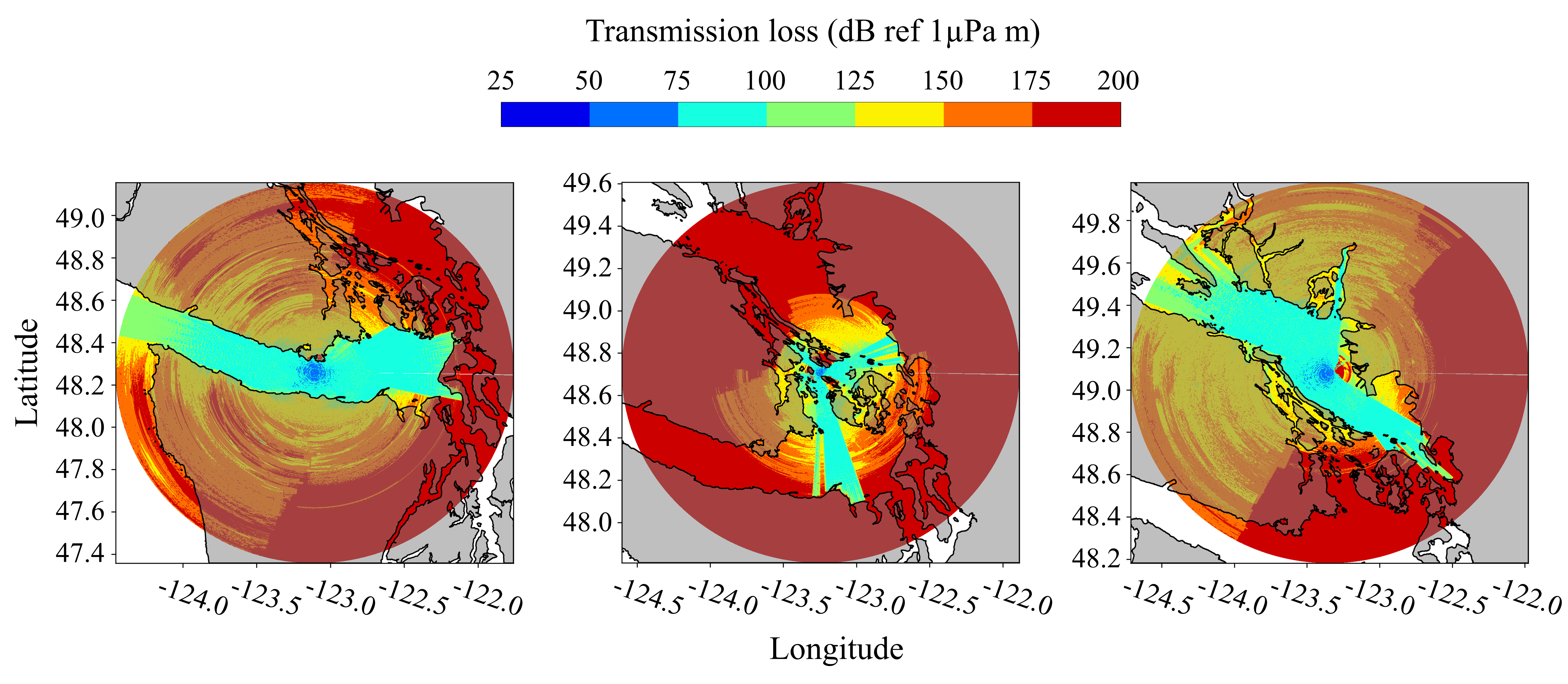
- Far-Field Noise Modeling: Uses the 3D Bellhop model to precompute a grid of transmission loss for different source locations and frequencies. A Gaussian Radial Basis Function (RBF) interpolation function is applied to enable efficient real-time retrieval of transmission loss values.

Figure 5: 3D Bellhop propagation loss contour in Strait of Georgia.
5. SRKW Modeling Unit
Modeling Southern Resident Killer Whales (SRKW) involves initializing the mammal nodes and assigning trajectories:
- The operator specifies the desired number of mammals in the 3D environment.
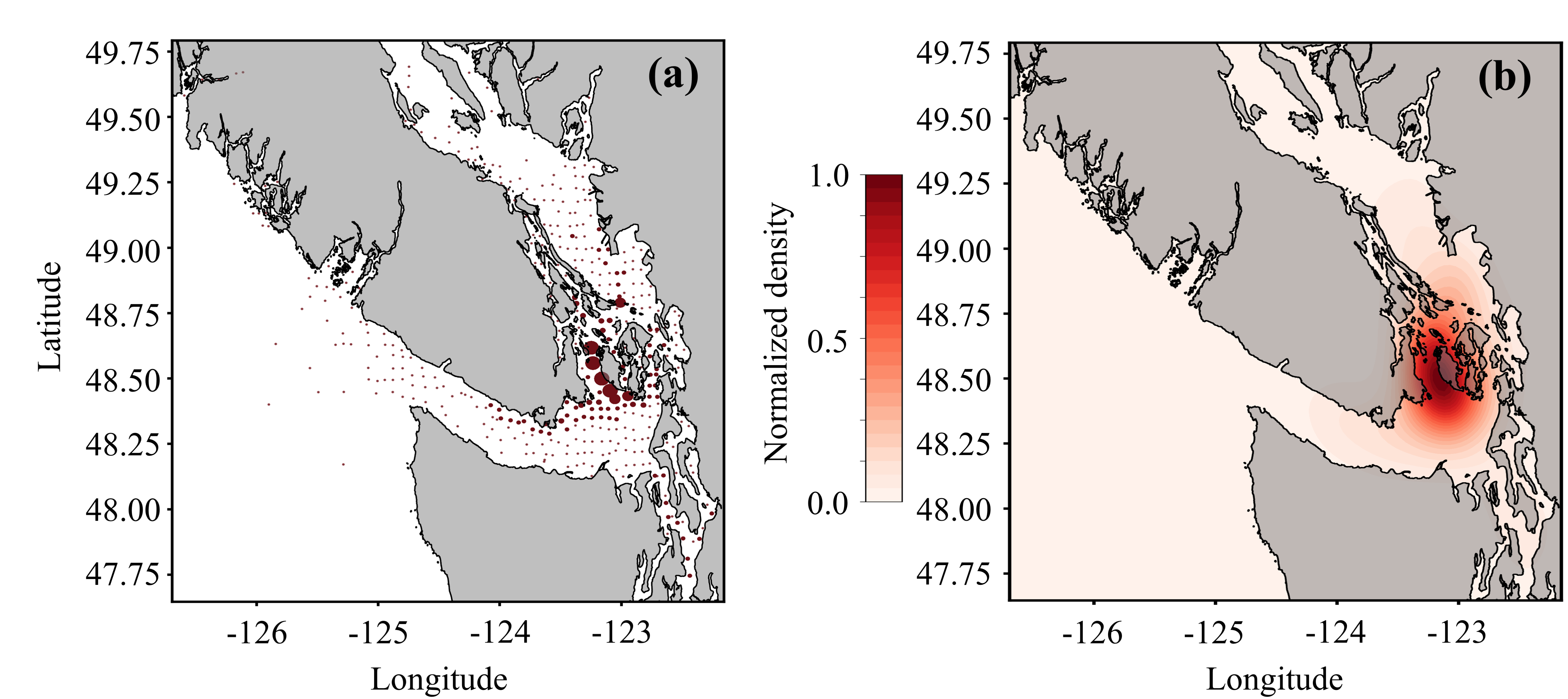
- Sighting data and maximum diving depth data are used to fit a Kernel Density Estimator (KDE) to determine initial locations.
- Parametrized audiograms based on species-specific hearing sensitivity are used to assess the impact of URN on marine mammals.

Figure 3: Mammal distribution data and Kernel Density Estimation for SRKW.
6. Route Planning Unit
The Open Motion Planning Library (OMPL) implementation of the Batch Informed Trees (BIT*) algorithm is used for route planning:
- The cost function is defined as the total transmission loss (TL).
- Route planning optimizes a series of states to maximize the summation of TL between the ship and the marine mammals.
- The ship is constrained to operate within valid configuration spaces, such as designated shipping lanes.
7. Speed Optimization Unit
The ship's route is segmented into multiple sailing legs of fixed duration. Each sailing leg has a specific velocity \(v_i\), which is optimized using a Genetic Algorithm to minimize the noise impact under voyage constraints.
8. Simulation and Visualization Unit
The simulation framework is a ROS-based system where the ship and mammals are represented as individual nodes programmed to exhibit specific behaviors within a 3D environment:
- The ship node receives navigation commands from the optimization unit on the route and speed to follow.
- Mammal nodes are launched with behavior directives from the SRKW modeling unit.
- The states of these nodes are continuously utilized by the optimization unit, creating a closed-loop system with iterative interactions.
- The visualization unit leverages Rviz2 for 3D rendering of the environment, providing real-time visualization of noise level contours relative to the ship's location.
- Time-series data such as vessel speed and NSL are plotted in real-time using PlotJuggler.

Figure 6: Visualization of 3D acoustic rays from a moving source.

Figure 7: Visualization of 3D acoustic transmission loss from a moving source.
Case Studies
This section presents the case studies conducted to demonstrate the applicability of MUTE-DSS and its comparison with real-world ship voyages. A total of three case studies are analyzed, benchmarking their results against the MMUTE-DSS optimal voyage:
- STAR KIRKENES
- STAR KILIMANJARO
- OKIANA
All ships departed from the Port of Vancouver, Canada. To simulate these voyages within the MUTE-DSS framework, AIS data was processed to extract the route and speed profiles. Missing entries in the raw data were interpolated to ensure consistency.
Results
The results of the simulations are ongoing and will be updated upon completion of the analysis.
Achievements
Throughout the project, the following milestones have been achieved:
- Developed a comprehensive Decision Support System (MUTE-DSS) for minimizing the impact of underwater radiated noise from ships.
- Implemented acoustic modeling using the JOMOPAN-ECHO model and 3D Bellhop model for efficient computation of noise source levels and propagation loss.
- Modeled the behavior and distribution of Southern Resident Killer Whales (SRKW) using Kernel Density Estimation.
- Applied advanced optimization algorithms, including BIT* for route planning and Genetic Algorithms for speed optimization.
- Created a ROS-based simulation framework with real-time visualization using Rviz2 and PlotJuggler.
- Conducted real-world case studies using AIS data to validate the DSS approach.
Conclusions
Summary of Findings:
- Developed a novel Decision Support System (MUTE-DSS) that integrates ship characteristics, operational conditions, and environmental factors to minimize underwater noise impact.
- Demonstrated the feasibility of real-time adaptive ship operations that are acoustically aware of their environmental footprint.
- Established a robust simulation environment for testing and validating noise mitigation strategies in marine operations.
Future Work:
- Complete the analysis of simulation results and refine the optimization algorithms based on findings.
- Extend the DSS to incorporate additional environmental factors and other marine species.
- Collaborate with maritime stakeholders to implement the DSS in real-world operational settings.
Final Remarks
This project demonstrates the integration of acoustic modeling, optimization algorithms, and simulation to mitigate the impact of underwater radiated noise from ships on marine life. By providing a tool for real-time decision support, MUTE-DSS has the potential to contribute significantly to marine conservation efforts and sustainable maritime operations.